If you have read one of my Georgia guides here on the blog before, then chances are you’ve also used one of my maps.
The free custom maps I create have always been some of the most popular resources on the site. As a visual planner myself – and someone who uses Google Maps for my own trip planning and research – I completely understand why.
I have been travelling around Georgia for almost 10 years now, and in that time I have built up a huge collection of saved locations – some of which appear in my guides and maps, but many of which have never had a home.
Now, for the first time, I am bringing everything together in one interactive map.
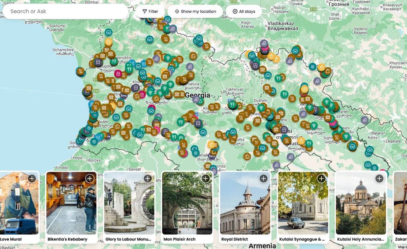
The Georgia Map is a new tool for travel planning. It contains more than 1,000 pins across the country, each one individually selected and researched by me, with original photography, visitor tips, and a helpful link.
You can think of it as an edited, personally verified version of Google Maps, made specifically for Georgia.
The major landmarks are all accounted for, but the real point of the map is to help you find the places in between: The random stops that turn a long drive into a memorable day, the detours that make a route more interesting, and the small details that are not plotted on Google Maps and are easy to miss if you don’t know where to look.
The map presents all of this information in a visual format, making it easier to see what there is to explore in a particular destination, what lies along a particular route, how regions fit together, and what you can visit on your way from A to B.
It also includes 16 ready-made itineraries that you can use as a framework for your own trip.
If you like travelling independently and piecing together your own route rather than following a standard checklist, this map was made for you!
The Georgia Map is hosted on Rexby, a travel-planning platform. You can access it in your browser or through the free Rexby app, with no subscription required.
Please note: This post contains affiliate links, meaning I may earn a commission if you make a purchase by clicking a link (at no extra cost to you). Learn more.
What’s inside The Georgia Map?
- 1,000+ individually selected places
- 16 ready-to-follow itineraries
- Travel tips
- Lifetime access to all future updates
- Offline access through the free Rexby app
- A free invitation for one travel buddy
1,000+ hand-picked locations
This is not a list of every attraction or business listed on Google Maps. Every pin has been selected and researched by me, because I genuinely think it is worth knowing about.
The map contains all of the major monasteries, castles, archaeological sites and hiking trails that first-time visitors look for, alongside waterfalls, museums, markets, wineries, and plenty more. I have also included bus stops, railway stations and other helpful pins, plus accommodation options for major destinations.
The map goes beyond the familiar highlights to include street art, Soviet-era mosaics, craft workshops, sulphur springs, unmarked viewpoints, and other small discoveries.
Some pins lead to a detailed guide here on the blog. Others document places I have visited and researched over the past decade but have never written about anywhere else.
Rather than scrolling through hundreds of listings and reviews yourself, you get a pre-filtered, carefully edited view of Georgia.

A curated collection of restaurants, cafes & bars
Food is a huge part of travelling in Georgia, but I did not want this map to become an enormous restaurant directory.
Instead, I have included a small selection of places I genuinely recommend and eat at myself, including special regional restaurants, family-run favourites, interesting cafes and wine bars, roadside lunch stops, and a handful of contemporary venues.
There are options for the places most travellers visit, but the map becomes especially valuable once you move beyond Tbilisi, Batumi and Kutaisi, where good recommendations can be harder to find.
16 original itineraries
The map also comes with 16 ready-made Georgia itineraries, as found on the blog – ranging from one-day scenic drives to longer regional road trips.
These are not generic versions of the standard Georgia circuit. They are routes I have designed around landscapes, heritage themes, lesser-used roads, and the places I most enjoy.
You can follow the old Ossetian Military Road through Racha-Lechkhumi, travel from Racha to Svaneti over the Zagari Pass, combine Guria’s tea heritage with its horse-riding traditions, explore the Javakheti Plateau, or follow a chain of Soviet-era monuments across Western Georgia.
Other itineraries cover Khevsureti, Meskheti, Upper Adjara and the Black Sea Coast, as well as some of my favourite cross-country routes.
Each one is designed to demonstrate how individual places connect into a journey. You can follow an itinerary exactly as I have structured it, save it as the starting point for your own trip, or borrow one section and combine it with your own plans.

Tbilisi essentials
Tbilisi is included in The Georgia Map, with everything you need to plan your first few days – including the major sights, my favourite neighbourhoods, and a curated selection of restaurants, cafes and bars.
For much deeper coverage, I am working on a separate Tbilisi Map with 200+ places to eat, drink, visit and explore across the city. That will be published soon, with a discounted bundle available for anyone who has already purchased The Georgia Map.
How to use The Georgia Map
I created this map to use at two different stages: First when you are planning your trip at home, and secondly when you are on the ground in Georgia.
Browse by category or tag
If you already know what you’re looking for, you can use the built-in categories and tags to narrow down the map and browse by theme.
Alongside broader categories such as hiking, restaurants and museums, I have created more specific tags for things including Brutalist architecture, Soviet mosaics, WWII memorials, Romanov heritage, Jewish heritage, mineral springs, street art, and urbex.
You can switch these filters on and off to quickly find places that match your interests, either across the whole country or within a particular area.
Explore visually & see what fits together
You can also explore the map itself. Zoom into a region you’re interested in, trace the road between two places you are considering, or just move around the map and see what catches your eye.
This is especially useful when you are still figuring out your route. The map is designed to answer the questions I constantly ask myself when planning my own travels: What else is nearby? What is on the way? What would I miss if I drove straight through?
Save places & build your own itinerary
As you browse, you can add the places that interest you to a Trip.
Inside a Trip, you can arrange your stops, move places between days, and see how your route comes together on the map. Rexby automatically lets you know the total distance and travel time for each day, with a link out to Google Maps for real-time navigation.
You can start a Trip from scratch, or use one of my 16 ready-made itineraries as a starting point and adapt it from there. For example, you might take my four-day Racha-Lechkhumi route, remove a stop that does not interest you, add a restaurant you found yourself, and spend an extra night somewhere along the way.
Use it alongside the blog & Google Maps
The Georgia Map is designed to work alongside both the blog and Google Maps.
Where I have a detailed guide or relevant article on the blog, I include a direct link from the pin. This means you can use the map to discover a place, then jump straight to the blog when you want more detailed information, practical tips, or transport instructions.
The pins also connect with Google Maps. When you are ready to visit a place, you can open the location for directions and navigation. I still recommend referring back to Google Maps for things such as live navigation, current opening hours, and recent reviews.
Use it offline
Before your trip, download the free Rexby app and save The Georgia Map for offline use. You can then access the map, pins and guide information even when you do not have a reliable internet connection.
While you are travelling, you can revisit places already saved to your Trip, browse the map to see what is nearby, and adjust your plans as you go.
Share your plans
One purchase includes a free invitation for one travel buddy. If you are planning with a partner or friend, you can both access the guide without having to buy it twice.
Lifetime access & regular updates
The Georgia Map is a one-off purchase with lifetime access. There is no subscription or recurring fee, and all future updates and additions are included.
When you purchase the map, access is linked to your Rexby account. You can open it whenever you like through Rexby in your web browser or through the free app.
The Georgia Map is an evolving resource – it already contains more than 1,000 places, but I still have a long list of pins to add and many parts of Georgia I want to revisit!
I will be updating the map regularly as I continue travelling around the country, adding new discoveries and photos, updating practical details, refining existing entries, and creating new routes as I research them.
If you have any questions about the map, please feel free to reach out!

If you would have done it in Google Maps, I am sure, more people would get it. And yes, it is possible to monetize it…
Why would I install ANOTHER untrustworthy app, just to find out it is not working when I need it? (especially just having 5k installs and not any ratings…)
maps.me was also cool once, then the new investor came and it was game over.
Good luck with your sales…
Google’s terms prohibit selling access to Google Maps or creating a paid product based on Google Maps.
You don’t need to download anything – you can access this map through your web browser on desktop or mobile.
Enjoy!